I am the ghost of groovymother.com. Woooooo!
This is an old page from Rod Begbie's blog.
It only exists in an attempt to prevent linkrot. No new content will be added to this site, and links and images are liable to be broken. Check out begbie.com to find where I'm posting stuff these days.
Filed under 'gps'
➠ November 29, 2009
Waze
Free car routing app for iPhone, which is using game mechanics (points & leaderboards) to crowd-source maps and traffic info. Initial prodding suggests it’s not ready for prime-time — you’re better off waiting for protonerds to fill up their data banks — but it might be worth watching in the future.
➠ June 8, 2009
TomTom for iPhone
One of the more interesting demos at Apple’s keynote today - TomTom are producing an iPhone app, plus a souped-up holster that doubles as charger and GPS “enhancer”. No hints given as to the price, but tealeaf-reading based on TomTom’s previous Palm apps, I’d guess around $150 for the software, and another $100 for the dock.
➠ August 29, 2008
Mio™ Knight Rider™ GPS Portable Navigation Device
Only surprising that it took this long to appear: “Features the voice of K.I.T.T. (William Daniels) providing turn-by-turn voice guidance”
➠ June 30, 2008
GLaGPS - Genetic Lifeform and Global Positioning System
Tweak your Garmin GPS to speak like Portal’s GLaDOS. Be wary if it instructs you to stop for cake.
➠ May 24, 2008
Biggest Drawing in the World
An artist uses the planet as his canvas, sketching a self-portrait by shipping a GPS-tracking briefcase around the world.
➠ March 5, 2008
Fire Eagle
Fire Eagle has launched — a broker for your physical location, which other applications can use to improve user experiences. It’s really just APIs and geekery at the moment, but the applications that use and enable it will start appearing pretty quickly — I’ve already got a couple of ideas.
➠ December 17, 2007
Dash Express GPS Video and Deets: True Traffic Reporting and Custom Maps for $599
I *really* like the look of this upcoming GPS — it gathers the speeds of other users over time and warns you when there’s slow traffic ahead, even on roads that SmartTraveller, etc. don’t cover. Will have to check them out at CES.
➠ June 1, 2007
…for some value of left
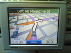
Road testing my new GPS in Cambridge gave this rather bizarre instruction (it's telling me to take a "left on Magazine St", but the illustration is actually taking a right onto Massachusetts Ave).
Proof that the roads of New England are too much for even the smartest of technology to deal with.
➠ March 9, 2007
Bostonist: It's not TomTom, it's CurtCurt
Curt Schilling voice for TomTom SatNav systems. The samples given are splendidly awful. “Errors lose ball games. Wrong turns make you late. Turn around when possible.”
➠ February 6, 2007
➠ November 22, 2006
DigiCam Geotagging with ZoneTag
This is a cool new feature in ZoneTag: Gather up your location information in your cellphone (either with a Bluetooth GPS, or just by cell-tower/location matching), then upload photos taken with your regular camera to Flickr and have ZoneTag geotag them automagically.
➠ November 6, 2006
Eddie Izzard voice for TomTom SatNav
Cool — I was getting bored of the bad Sean Connery impression on mine.
➠ September 5, 2006
RoboGEO: Map Your Photos
Software to merge the timestamps on your photos with the route file from your GPS to automagically geocode your photos ready for Flickr.
➠ July 13, 2006
➠ July 8, 2006
About This Site
This is an archive of groovmother.com, the old blog run by Rod Begbie — A Scottish geek who lives in San Francisco, CA.
I'm the co-founder of Sōsh, your handy-dandy guide for things to do in San Francisco this weekend.